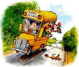
The
RoadKill project is designed to involve students and teachers with scientific
monitoring of an environmental parameter using the Internet and to increase participant
awareness of motor vehicle hazards with wildlife. Monitoring roadkill brings excitement
and stimulating conversation to all.
The
unmotivated student becomes extremely interested in a gruesome subject. Students
soon realize that there are many animals killed or injured by motor vehicles.
Roadkills vary depending on the population of the community, the amount of traffic,
and the type of roads. Migratory patterns of animals and habitat of the local
area will also affect the number of roadkills.
Students
and teachers will collect roadkill data in their community for analysis as well
as compare their data to other areas participating in the project. Overall, the
roadkill project can be an important addition to an environmental science education.
The
RoadKill project is applicable to students of all ages and ability across many
disciplines. Teachers may participate in this project as long as their school
has access to the World Wide Web in order to submit and download the data.
The
purpose of this project is to give students an awareness and understanding of
the natural world around them. Often, humans and wildlife do come into conflict.
Roadways have divided habitat and natural corridors of travel for many species
of wildlife, and roadkill statistics are evidence of this phenomenon.
National
Educational Technology Standards
The
RoadKill 2012 project addresses the following National Educational
Technology Standards. The content standards are for middle school
students; (Grades 4-9) but are easily adapted for elementary and
high school students. We hope these standards will provide a valuable
resource for teachers seeking to incorporate the RoadKill project
into their core curricula.
Standard
2 Demonstrate knowledge of current changes in information technologies
and the effect those changes have on the workplace and society.
Standards
3 and 5 Use content-specific tools, software, and simulations (e.g.,
environmental probes, graphing calculators, exploratory environments, Web tools)
to support learning and research.
Standards
3 and 6 Apply productivity/multimedia tools and peripherals to support
personal productivity, group collaboration, and learning throughout the curriculum.
Standards
4, 5 and 6 Design, develop, publish, and present products (e.g., Web
pages, videotapes) using technology resources that demonstrate and communicate
curriculum concepts to audiences inside and outside the classroom.
Standards
4 and 5 Collaborate with peers, experts, and others using telecommunications
and collaborative tools to investigate curriculum-related problems, issues, and
information, and to develop solutions or products for audiences inside and outside
the classroom.
Standards
5 and 6 Select and use appropriate tools and technology resources to
accomplish a variety of tasks and solve problems.
Standards
2, 5, 6 Research and evaluate the accuracy, relevance, appropriateness,
comprehensiveness, and bias of electronic information sources concerning real-world
problems.
National
Science Education Standards
We
have included a correlation of the RoadKill 2012 project curriculum to the National
Science Education Standards. The chart below shows how the RoadKill project correlates
with specific National Science Education Standards for Grades 5 through 8.
Content
Standard A: Science As an Inquiry
Students
learn about scientific inquiry and develop the abilities necessary to perform
it.
Content
Standard C: Life Science
Students
should develop an understanding about the structure and function of living systems,
reproduction and heredity, regulation and behavior, populations and ecosystems,
and the diversity and adaptations of organisms.
Content
Standard E: Science and Technology
Students
should learn about science and technology and develop the abilities necessary
for technological design.
Content
Standard F: Science in Personal and Social Perspectives
Students
should develop an understanding of personal health, populations, resources, environments,
and natural hazards. Students should also learn about the role of science and
technology in society.
Content
Standard G: History and Nature of Science
Students
should develop an understanding about the nature and history of science and learn
that science is a human endeavor.
Teacher
Objectives
To use the Internet to send and receive roadkill data from other participating
schools.
To use roadkill data to teach ecological principles.
To use roadkill data in ways to portray information graphically.
To use roadkill data to teach elementary concepts in statistical analysis.
Student
Objectives
To compare the data from participating schools.
To recognize animal species in their community.
To understand the migratory patterns of different animals.
To understand reciprocal effects between humans and wildlife.
To predict which type of animal will be most and least killed by motor vehicles.
To understand the habitats and ecological importance of small and large mammals,
reptiles, and birds.
To compare the relationship between geography and topography and the types and
number of roadkill in different locales and states
Project
Protocol
The project protocol for RoadKill 2012 reflects the use of our online database
software program. Please click
here to read the "RoadKill Database Note" file. This section describes
the database and how you can download the information to your comupter. (You should
print a copy of this page for later reference).
From March 4th to April 28th each student is assigned a road that
is frequently traveled to and from school. This road is to be
monitored at least twice a day for an eight week time period.
Once a student observes a flattened "roadent", a report is then
entered on a designated RoadKill chart that you can provide
in your classroom.
On each Monday, the teacher will ask for the numbers of animals that were killed
on the roads, the road classification, and speed limit along with the number of
miles monitored by each student.
All participants are expected to participate in 7 of the 8 weeks of monitoring.
Most schools have a one week vacation during this time period, and information
need not be collected during that week. Weekly data reports should be sent to
the RoadKill database during each week of the project. It is important to send
these reports on time as other teachers and students will be using the data for
weekly analysis.
Time
Frame
The
RoadKill monitoring project will run from March 4th through
April 28, 2012. Teachers and students may continue to collect and
send data after these dates if they wish, entering individual
data sets according to the date that it was collected. This
will take some re-programming for our online database so if
you do have an interest to continue (and there are enough requests
for this) we will make the database modifications.
During the time frame of March 4th through April 28th please report
the data for each week within 7 days of the last day of that
week. For example, week one should be reported no later than March
17th. The RoadKill monitoring weeks are listed below:
Week
#1
March
4-10, 2012
Week
#2
March
11-17, 2012
Week
#3
March
18-24, 2012
Week
#4
March
25-31, 2012
Week
#5
April
1-7, 2012
Week
#6
April
8-14, 2012
Week
#7
April
15-21, 2012
Week
#8
April
22-28, 2012
The success of this project depends on timely reporting. Data summaries can be
obtained by searching the RoadKill database. Instructions for downloading the
RoadKill database and working with the information can be found in the RoadKill
Database Notes file.
Sending
Data as a Group
Teachers
may send their data as a group during this 8 week project, but must send different
reports for each classified road setting. For example, if your school is located
in a urban setting, there could be as many as 3 reports sent in each week: data
for streets with speed limit less than 35 mph.; data for roads above 35 mph.;
or data for Interstate Highways.
How
to Count
For each type of roadway listed above, the teacher and/or students must pick a
specific distance to monitor. Each student should be given a specific distance
along a chosen road to monitor (for example a 0.5 mile section of a street or
several miles on a highway). As mentioned earlier, road classifications, conditions,
and environments can change very quickly over short distances. Thus one student
should monitor only one type of a road classification.
Teachers need to total the miles for each road type for their group of students
that are participating. (i.e. 17 miles for a suburban highway would include all
reports from students that have this particular type of road).
What
to Count
You count all animals that are found dead either in the roadway or along the sides
of the roadway. You may record any animal, bird or reptile. If the "roadent" does
not appear on the database input form provided, please add your data for that
animal to the comments category specifying the name of the animal and how many
you are including.
Some
Menus in the RoadKill Data Input Form - The following is a discussion of
various menus that you will see on the RoadKill Data Input Form. Please take the
time to read through each area that is outlined so that you will be knowledgeable
when selecting the options for data submittal.
Identification
of Your School/Organization
Elementary
School
Middle
School
High
School
Home
School
College/University
Member
of Environmental Organization
Member
of General Public
It
is important to not only select the correct school/organization option from the
menu but also to identify the name of your school/organization in the space that
follows that in the input form. Some of the searches that will be done of the
data may use this criteria for a search value therefore it is very important
to correctly fill in these spaces. If you are from "Member of an Environmental
Organization" be sure to include the name of your organization in the next space.
If you are reporting from the "Member of General Public" menu then you should
include the term "General Public" in the School/Org. Name space on the data input
form.
Selection
of the Week Number
Week
#1 March
4-10, 2012
Week
#2 March
11-17, 2012
Week
#3 March
18-24, 2012
etc.
Between
March 4th - April 28th, be sure to select the appropriate week
number for the data you are to submit. Seasonal differences
in the spring can have a dramatic effect on the amount and
type of roadkill. One of the parameters we will be looking
at very closely is the change to daylight savings time. Vacations
should also be reported by sending in a report form with only
the identification information and with "vacation" written
in the comment section of the database.
Lunar
Phases
Week
#1 March 4-10, 2012
Full Moon
Week
#2 March 11-17, 2012
Full Moon to Last Quarter
Week
#3 March 18-24, 2012
New
Moon
Week
#4 March 25-31, 2012
New Moon to First Quarter
Week
#5 April 1-7, 2012
Full
Moon
Week
#6 April 8-14, 2012
Full Moon to Last Quarter
Week
#7 April 15-21, 2012
New
Moon
Week
#8 April 22-28, 2012
New Moon to First Quarter
Entering
data by week number poses a problem in getting the "exact" lunar phase. During
a typical seven day period the moon actually passes from one "major" phase (new,
first quarter, etc.) to another with "minor" phases (waxing crescent, waning gibbous,
etc.) occurring in between. We could not program our database software for an "auto-fill"
field so you will have to bear with the entry process for this. Please consult
the above referenced table for the phase to enter for each week depending on the
date for your collected data.
Road
Classifications
Rural
Road - 35 mph or less
Rural
Highway - 35 to 55 mph
Suburban
Road - 35 mph or less
Suburban
Highway - 35 to 55 mph
Urban
Road - 35 mph or less
Urban
Highway - 35 to 55 mph
Interstate
Highway - 55 mph or more
We
tried to include all types of roadways with this general menu option but obviously
there will be some of you that are monitoring types of roads that may not exactly
fit one of these categories. You should select the closest possible description
from the list and use that as your classification. It is important not to mix
collected data between two different road classifications. If you are monitoring
more than one classification of roadway you should make separate data submittals
to the RoadKill database.
Miles
Monitored
Here you indicate the number of miles monitored for each group data set.
RoadKill
by Species
Here you enter of number of roadkill for each "roadent". You do not need
to enter anything for animals that are on the database list that you have not
recorded in your monitoring period. If you identify a "roadent" not on the list,
please enter its name and number observed in the comment section of the data base.
The
term U.R.P. means Unidentified Road Pizza, a term that means simply that
there was a creature on the road but too many vehicles hit this hapless victim
and made it hard to identify. You will find a field for URP on the list so please
use this classification for those unrecognizable victims.
We
are also interested in other comments such as weather, road conditions that are
not listed under "Road Classifications" or other conditions that you
think might prove useful to those doing research with your data.
Subscribe
to the RoadKill Message Board
-
All messages that are posted to the message board can be received via your primary
email account. This is a good way to stay current with postings. To subscribe
to the message board all you have to do is go
to the board, and fill in the menu on the left sidepanel of menus under "Follow RoadKill '12". This will give you the option of
signing up. You can also unsubscribe from the message board at any time. You should
note however, that you must be at the message board to reply to
any messages.

 The
RoadKill project is designed to involve students and teachers with scientific
monitoring of an environmental parameter using the Internet and to increase participant
awareness of motor vehicle hazards with wildlife. Monitoring roadkill brings excitement
and stimulating conversation to all.
The
RoadKill project is designed to involve students and teachers with scientific
monitoring of an environmental parameter using the Internet and to increase participant
awareness of motor vehicle hazards with wildlife. Monitoring roadkill brings excitement
and stimulating conversation to all.  The project protocol for RoadKill 2012 reflects the use of our online database
software program.
The project protocol for RoadKill 2012 reflects the use of our online database
software program.